


P U B L I C I D A D E

"Porto Maravilha": Engineering proposes dialogue between past and future
With investments that total R$ 7.6 billion (US$ 3.8 Bn), concessionaire takes on the challenge of requalifying an area of 5 million square meters in Rio de Janeiro’s Port Zone while reconciling the preservation of the region’s history with modern urban design standards
By: Paulo Espírito Santo
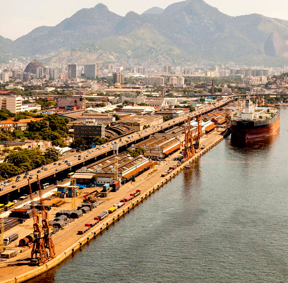
Rio de Janeiro is presently the scene of two of the greatest urban interventions that are underway in Brazil, both in the dimension of construction works as well as in the volume of investment. One is the construction of Line 4 of Rio’s Metro, which was the subject of a special report in the April issue of Grandes Construções. The other is the ‘Porto Maravilha’ (or Port Marvel) project - commanding the investment of R$ 7.6 billion (US$ 3.8 Bn) - which proposes to requalify/renew an area of 5 million square meters in the state capital’s Port Region, rescuing it from a process of decades of neglect and deterioration. More than just a collection of works, the mega-venture is a pioneering experience in Public Private Partnerships (PPPs) for concession of the execution of public services, management of urban spaces and the realization of infrastructure projects to private enterprise as part of one of the largest urban renewal projects in the world. Hence the name given to the project by the concessionaire: “Operação Urbana Porto Maravilha” or Urban Operation Port Marvel.
The example came from Barcelona - Spain where, in the early 1990s, a major project for restructuring of the city’s port region was executed making it the greatest legacy handed down to society after the 1992 Olympic Games. The concepts that guided the Catalan project serve as reference until today for any intervention performed in the region.
A lot more is expected of Operação Urbana Porto Maravilha. If the model succeeds, it will become a new paradigm to be adopted not only in other areas of the city, but in other Brazilian capitals and medium-sized cities as well. As in Barcelona, the deadline for completion of the set of actions to be executed in Rio de Janeiro is the Summer Olympic Games that the city will host. The date is 2016 but the fruits of the operation are expected to be reaped for many years to come after the end of the competitions.
To get the project off the drawing board, Rio de Janeiro’s City Hall called for a tender through the ‘Port Region Urban Development Company’ (CDURP) and hired “Concessionária Porto Novo SA”, established via the association of the Norberto Odebrecht construction company, Carioca Engenharia and OAS. The model of concession adopted was that of Administrative Concession (“Concessão Administrativa”) effective for a period of 15 years. The complete plan of revitalization includes public services (utilities) such as the renewal of sewage systems, drainage, street lighting, street cleaning and collection of public and private garbage. For this purpose, the city is implementing an underground drinking water network of 122 km; 36.5 km of drainage networks and 11 km of drainage galleries; 84 km of sewers, 26 km of gas pipelines and ducts for the optic fiber cable network.
 Such actions will directly benefit 32,000 inhabitants, especially those who inhabit the neighborhoods of Gamboa, Santo Cristo and Saúde, and the hillside neighborhoods of Pinto, Telégrafo, Livramento, Conceição and Providência which will receive a chairlift. Besides undergoing urban renewal, the Morro do Pinto will gain a reservoir with a capacity of 15 million liters of water.
The plan also includes the maintenance, conservation and paving of streets and the execution of 650,000 square meters of sidewalks, tree pruning, and maintenance of parks, gardens and public monuments, as well as the management of vehicle traffic by a modern Operational Control Center, a new traffic signal network and a traffic monitoring system with 30 cameras located at strategic points.
The entire infrastructure network will be placed underground. Electrical, telephone, internet and cable TV wiring, for example, will go underground doing away with concrete poles on the sidewalks once and for all. According to the concessionaire, the reorganization of the city’s underground prepares the area to receive the best telecommunications network in Latin America, with a high-speed connection compatible with the most modern cities in the world.
New thoroughfare system
 To enable the development of the region as an important hub, a reference for tourism, and a commercial and business center, and to spur the region’s real estate development, the entire network of streets and roads will be restructured and will require large works and heavy investments
Presently, the area of operation of the Porto Maravilha project consists of a quadrilateral of thoroughfares whose boundaries include the four most important avenues of the city’s center: Francisco Bicalho, Rodrigues Alves, Rio Branco and Presidente Vargas. This is a region of convergence where, on the average, over 100 thousand people circulate per day. The area is interconnected by major expressways such as Avenida Brasil, the Linha Vermelha and the Rio-Niterói Bridge. It is a few miles from the Tom Jobim Airport and from train stations and the subway. This region has two bus terminals and a bus station.
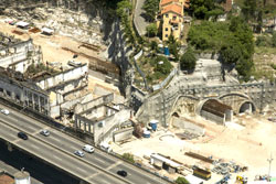
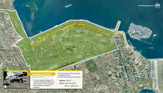
The renewal of the region’s network of thoroughfares includes the construction of two new roads that will play a ‘structuring’ role. One of these roads will be the ‘Avenida do Binário do Porto’ which will have 3.5 km in length and will cross the entire Port Region with three lanes in each direction and two tunnels. This thoroughfare complex will receive traffic that currently circulates along Avenida Rodrigues Alves.
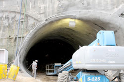
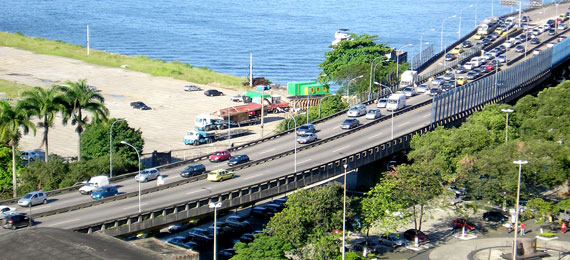
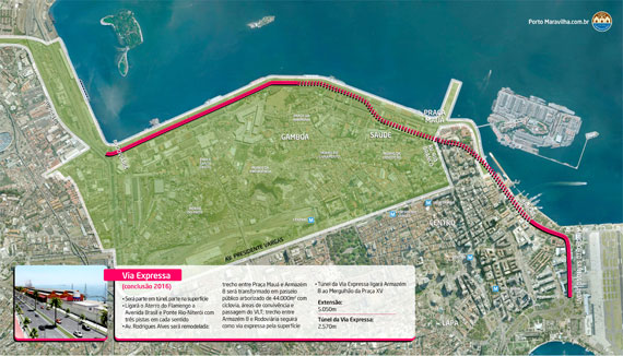
The other route will be the Avenida Expressa (Express Avenue), with 5.05 km in length, three lanes and two parallel tunnels, each 3.6 km long. This route will act as an expressway, receiving only thru traffic that crosses the Port Zone, along the borders of the area parallel to the warehouses of the Port, bound for Santos Dumont Airport or the Aterro do Flamengo, or in the opposite direction, toward the Warehouse 6 at the exit of Port Zone. The Avenida Expressa will replace the 4 kilometers of the Elevado da Perimetral which will be demolished.
Part of the Avenida Rodrigues Alves will make way for the construction of a large public walk planted with greenery between Armazém 8 and Praça Mauá, with 44 thousand square meters in area. With that, a large area will be created for socializing, traffic of pedestrians and the Light Rail Transit system.
These two complexes of avenues will increase the region’s capacity to handle traffic by 40%. By 2015, it is expected that the traffic capacity of the region will reach 10,500 vehicles per hour.
Why demolish the Perimetral?
The demolition of the Perimetral (an elevated expressway) caters to needs that go far beyond aesthetics and is consistent with the most modern conceptions of mobility. When it was built in the early 1950s, this ‘flyover’ expressway, which connects Rio’s Caju borough to Santos Dumont Airport aimed to serve as an alternative to the routes of the time which were congested and could not be enlarged. It was also the solution establishing a link between the North and South zones without having vehicles pass through the center of the city center. At the time, elevated avenues akin to viaducts emerged as a strategy to handle traffic in major cities worldwide.
Today, technical studies show that removing the Perimetral is essential. One reason is the high cost involved in keeping the Perimetral’s gigantic structures saturated while still investing in the renewal projects required to recover areas that were degraded by the construction of these viaducts.
The decision to demolish viaducts of this size is not something without any foundation invented by the city of Rio. A study conducted by the Institute for Transportation & Development Policy (ITDP) found that 17 cities in the United States, Europe and Asia have demolished similar structures in order to improve traffic. One such example is the city of San Francisco – California which demolished a 2.6 km overpass in the port area during renewal. Today, the location known as ‘Embarcadero’, along the port’s docks, is one of the city’s most visited tourist spots. Seoul in South Korea also demolished a structure of 9.4 km in length. Nearly half of the location’s residents had moved away due to the extent of the deterioration caused by the overpass. The conclusion was that the structure was not a good solution for traffic or for neighborhoods.
Light Rail Transit integrating modals
The Porto Maravilha project includes the construction of a system of Light Rail Transit (LRT) with six lines and 42 stations, for a total of 28 km, which will be integrated with the conventional bus system and the lines of Bus Rapid Transit (BRT) that already operate in center of the city in addition to a subway, trains, and ferries that connect Rio and Niterói. Integration with other means of transport will improve traffic in the downtown area, reducing the circulation of buses and cars.
The average distance between stations is 400 meters. Each group of LRT cars can carry up to 450 passengers and the maximum waiting time between trains is from 2.5 to 10 minutes, depending on the line.
Power for the system will be provided via an electrified ‘third rail’ in certain segments of the line and at train stops. That means no overhead power lines with suspended electric cables. In addition, the energy generated each time the train brakes will be reused by a device called a ‘supercapacitor’. These technologies are now used worldwide, but only separately. What does not yet exist is the combination of these two systems which will provide greater security/reliability and economy. The project provides for accessibility for the handicapped in all of the LRT’s cars and determines the installation of air-conditioning.
The six LRT lines are expected to be operating by 2016. The implementation of this new means of transport is expected to cost an estimated R$ 1.1 billion (US$ 550 million), of which R$ 500 million (US$ 250 million) will be financed by federal funds, the government’s ‘Programa de Aceleração do Crescimento’ (PAC – Program for Acceleration of Growth) for Mobility, and the remainder will be ensured via PPP (Public-Private Partnership).


Av. Francisco Matarazzo, 404 Cj. 701/703 Água Branca - CEP 05001-000 São Paulo/SP
Telefone (11) 3662-4159
© Sobratema. A reprodução do conteúdo total ou parcial é autorizada, desde que citada a fonte. Política de privacidade